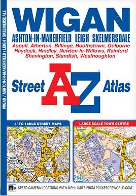
A-Z Street Atlas - Wigan
SKU
AZ359
Trade Price
£5.95
Ex VAT (Free UK Delivery Over £125)
Ex VAT (Free UK Delivery Over £125)
normally in stock

| Unit RRP: | £5.95 |
| VAT Rate: | 0% |
| Unit Price (ex. VAT): | £5.95 |
| Unit Price (inc. VAT): | £5.95 |
| Units in Case: | 1 |
| Profit per Unit: | £0.00 |
| Profit per Case: | £0.00 |
| Profit on Return (%): | 0.00% |
| Mark Up (%): | 0.00% |
Calculate Your Profit:
| Profit per Unit: | N/A |
| Profit per Case: | N/A |
| Profit on Return: | N/A |
| Mark Up (%): | N/A |
Scale: 4 inches to 1 mile (6.3cm to 1km)
Includes:
•Standish
•Aspull
•Westhoughton
•Atherton
•Little Hulton
•Boothstown
•Golborne
•Newton-Le-Willows (part)
•Blackbrook
•Chadwick Green
•Rainford (inset)
Also included is a large scale town centre map of Wigan.
Postcode districts, one-way streets and safety camera locations with their maximum speed limit are featured on the mapping.
The index section lists streets, selected flats, walkways and places of interest, place, area and station names, hospitals and hospices covered by this atlas.
| Series | Street Atlas |
|---|---|
| Activity | Driving |
| Brand | A-Z |
| Continent | Europe |
| Country | England |
| Region | Greater Manchester |
Write Your Own Review
We found other products you might like!