Pocket Mountains - Oban And North Argyll
Ex VAT (Free UK Delivery Over £125)


| Unit RRP: | £6.99 |
| VAT Rate: | 0% |
| Unit Price (ex. VAT): | £4.19 |
| Unit Price (inc. VAT): | £4.19 |
| Units in Case: | 0 |
| Profit per Unit: | 0 |
| Profit per Case: | £2.80 |
| Profit on Return (%): | 40.06% |
| Mark Up (%): | 66.83% |
Calculate Your Profit:
| Profit per Unit: | N/A |
| Profit per Case: | N/A |
| Profit on Return: | N/A |
| Mark Up (%): | N/A |
Pocket Mountains - Oban And North Argyll
Argyll and Bute is the second largest region in Scotland, covering over 7000 square km, yet fewer than 90,000 people live here, almost half of them in areas classified as ‘remote rural’.
This guidebook covers a large swathe of Mid and North Argyll, sweeping inland from the fractured western seaboard between Crinan and Appin to Arrochar and Bridge of Orchy on the region’s eastern periphery. Between these four points lies a landscape awash with sea lochs, with Inveraray roughly at the geographical centre. There are no large urban areas here and Oban is the largest settlement. Although the road network and public transport infrastructure are good, many routes feel off the beaten track. This is not only down to the low scattered population but also to the indented coast and its many islands, the sea lochs encroaching deep inland, the elongated freshwater lochs and the mountainous interior – making road travel much more convoluted than direct ‘as-the-crow-flies’ distances would suggest.
As well as its renowned west coast and its sequence of accessible islands, and many great lochs, tumbling rivers and iconic mountains, this region also boasts ancient, wildlife-rich woodlands and several fine gardens. Add to this the Crinan Canal, often described as ‘the most beautiful shortcut in Scotland’, and some of the most important historical sites in the country and you have all the makings of a fascinating walking destination.
History
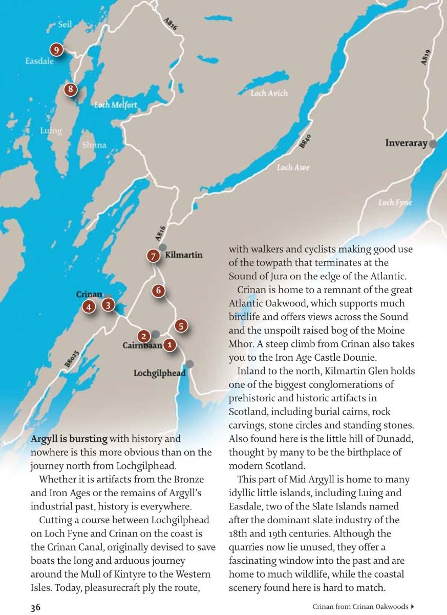
Argyll means ‘Coastland of the Gaels’, referring to the early Gaelic-speaking Scots, who populated much of Scotland’s western seaboard. There is plenty to learn when walking in Mid and North Argyll as a good deal of Scotland’s early history rests here, particularly in Kilmartin Glen, where more than 400 prehistoric and historic sites sit within a 10km radius.
The low, rocky hill of Dunadd (‘Fort of Add’ – the River Add flows around its base), a few miles north of Lochgilphead, rises from Kilmartin Glen and was at the centre of the ancient Kingdom of Dál Riata, the name given to the kingdoms of Scotland and Ireland.
It was where Irish settlers, known as the Scotti, arrived in the 6th century AD, and these people eventually gave their name to Scotland. Some 300 years later, the Gaels of Dál Riata joined the Picts of eastern Scotland to establish the kingdom of Alba, after which the control and influence of Dunadd rapidly waned.
Even before the Scotti arrived, humans had begun to leave their mark on the Argyll landscape. Kilmartin Glen contains several burial cairns and standing stones constructed around 4000 to 5000 years ago, while the rock carvings at nearby Achnabreac are believed to date from the same time. Castle Dounie, near Crinan, and Dun na Cuaiche, above Inveraray, hold the remains of Iron Age forts. Argyll’s history over the last few centuries has been a turbulent one, with many battles fought over the loch-bound Castle Stalker, near Appin, Dunstaffnage Castle, a little north of Oban, and Gylen Castle, perched on a rocky outcrop on the island of Kerrera.
These strongholds held strategic positions along the coast and bore witness to civil warfare between rival clans (particularly the Stewarts, Campbells and MacDougalls) and seaboard battles with Viking raiders. More recently, the landscape has been utilised for agriculture, fuel and timber. The islands of Easdale and Luing were central to the slate industry that for more than 200 years roofed a huge number of Scotland’s buildings, while Lismore, a little off the coast from Port Appin, had a thriving limestone industry. These provided employment for thousands of people over the course of the 18th and 19th centuries, as did the Bonawe Iron Furnace during its 123 years of production. It is only in the last 70 years that the road network and public transport infrastructure have opened up Mid and North Argyll. Prior to this, ferries were a standard mode of transport, linking many isolated rural communities both on the islands and along the indented sea lochs.
Today it is the outdoors industry, including walking, cycling, sailing and wildlife-watching, that is central to a local economy which is still predominantly rural. Lochgilphead remains the region’s main administrative centre and – along with towns and villages such as Appin, Arrochar, Benderloch, Inveraray and Oban – provides an ideal base for exploring.
The natural environment
The landscape of Argyll has many facets; great muscular mountains such as Ben Cruachan, low-lying agricultural plains along its centre and little islands cast adrift from the mainland yet only requiring a short ferry journey into a more peaceful, timeless backdrop. The elongated sea lochs of Etive, Fyne and Linnhe claw deep into the coastline while their freshwater cousins, including Loch Awe and Loch Avich, punctuate huge swathes of forest and woodland.
The rocks that form the basis of Argyll date back more than 600 million years to the Dalradian Period, while the obvious arrangement of the land on a southwest to northeast plane is down to an earth movement that occurred 470 million years ago – look at a map of Argyll and you can see the parallel lochs, valleys and ridges trending northeast from the coast.
Mid and North Argyll is also home to some of the best remnants of the renowned oakwoods that once cloaked much of Europe’s Atlantic seaboard. Examples can be found at Crinan, Dalavich and Glen Nant, dating back some 7000 years when oak, along with birch, elm and hazel, began to colonise this rough, rocky setting, aided by a warm, moist climate. Around 6000 years ago, Mid and North Argyll was a dense, temperate rainforest with many now extinct animals, including bears and wolves, hunted by humans. Over time, the forest was cleared ever more extensively, and the human impact on the land has continued apace – from cereal cultivation, introduced some 800 years ago, right up to the present day with the hydroelectric schemes at Loch Glashan and within Ben Cruachan.
This is, nevertheless, a landscape still populated by much wildlife; from the humble redstart and pied flycatcher in summer woodlands through to guillemots and terns on the coast and, of course, the kings of the skies, golden and white-tailed sea eagles.
How to use this guide
Almost all of the walks in this guide can be completed within half a day, leaving plenty of time to explore the natural attractions and historic sites you encounter along the way. Many of the walks are accessible by bus or train while several are reached by a short ferry journey. Basic public transport information is included in this guide, but details/times can change so please check before you set out (travelinescotland.com). The majority of the routes are low-level and take advantage of Argyll’s excellent network of paths. It is not advisable to stray from the routes onto farmland or near exposed cliffs and, where livestock is present, dogs must be kept on leads. A few of the routes cross steep hill or mountain terrain where good mapreading and navigation skills are necessary in poor weather. Winter walking brings distinct challenges, particularly the limited daylight hours, whilst strong winds along the coast and over higher ground can occur throughout the year.
Preparation for a walk should begin before you set out, and your choice of route should reflect your fitness, the conditions underfoot and the regional weather forecasts (mwis.org.uk). Even in summer, warm, waterproof clothing is advisable and footwear that is comfortable and supportive with good grips is a must.
None of the hillwalks or longer routes in this guide should be attempted without the relevant OS Map or equivalent at 1:50,000 (or 1:25,000) and a compass – and you should know how to navigate using a map and compass. Under the Land Reform (Scotland) Act of 2003, there is a right of public access to the countryside of Scotland for recreational purposes. This right depends on whether it is exercised responsibly, while landowners have an obligation not to unreasonably prevent or deter those seeking access.
The responsibilities of the public and land managers are set out in the Scottish Outdoor Access Code (outdooraccess-scotland.com).
| Series | 40 Favourite Walks |
|---|---|
| Brand | Pocket Mountains |
| Continent | Europe |
| Country | Scotland |