Pocket Mountains - Moray
Ex VAT (Free UK Delivery Over £125)


| Unit RRP: | £6.99 |
| VAT Rate: | 0% |
| Unit Price (ex. VAT): | £4.19 |
| Unit Price (inc. VAT): | £4.19 |
| Units in Case: | 0 |
| Profit per Unit: | 0 |
| Profit per Case: | £2.80 |
| Profit on Return (%): | 40.06% |
| Mark Up (%): | 66.83% |
Calculate Your Profit:
| Profit per Unit: | N/A |
| Profit per Case: | N/A |
| Profit on Return: | N/A |
| Mark Up (%): | N/A |
Pocket Mountains - Moray
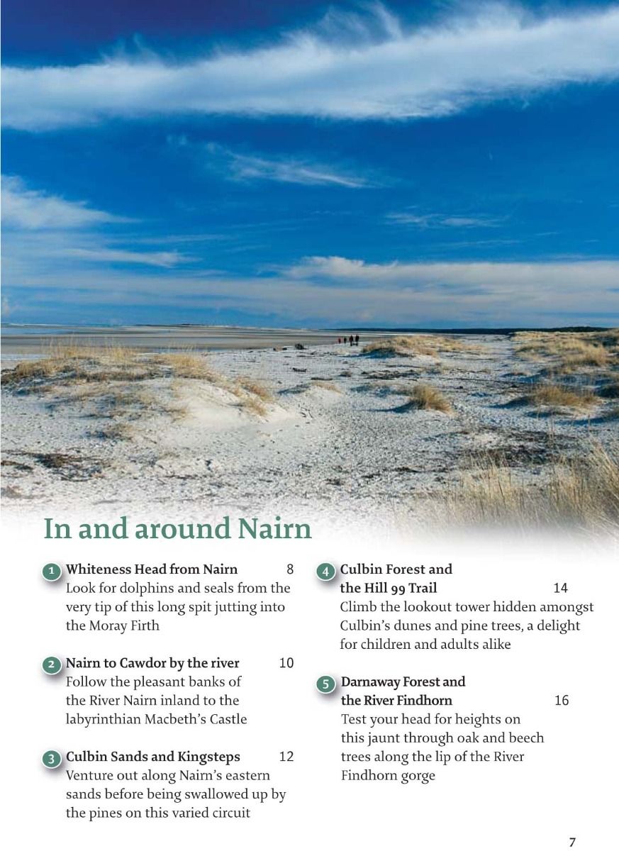
This book covers the southern coastline of the Moray Firth, from just east of Inverness to the North Sea at Rattray Head. The area includes Nairn, the whole of Moray, including Forres, Dufftown, Buckie and Elgin, and the picturesque fishing villages of North Aberdeenshire such as Gardenstown, Crovie and Pennan. In addition to the coast, with its vast sandy beaches and intricate rock formations, cliffs and coves, the landscape extends inland towards the fringes of the Cairngorms. Here are the moors and glens, habitat of red deer and golden eagle, and the heartland of malt whisky – Speyside.
Such variety makes for a fascinating range of walks which pass distilleries, scout out the Moray Firth dolphins, hike across rolling farmland and gentle moors, watch red squirrels and birds amongst the pines and dunes of the coast, and explore some of Scotland’s most picturesque villages with tiny cottages hemmed in between the cliffs and the sea.
Using this guide
This guide contains 40 short to moderate walks, most of which can be undertaken in half a day. Whilst many follow prepared and waymarked paths, some cross open hills or moor which can be boggy or steep. Although the area is known for its good sunshine record, the weather can be changeable, with cold winds and often heavy snowfall in the winter. Most of the walks require waterproof footwear and clothing. A sketch map accompanies each route, but walkers should also carry an OS map to aid navigation on all but the most straightforward routes.
The few walks that are suitable for all-terrain baby buggies are highlighted at the start of the relevant routes. Many routes are, however, ideal for well-clad families, including beaches at Burghead Bay and Cullen, red squirrel-spotting at Culbin and Roseisle and a mountain challenge for little legs on Ben Aigan. On walks starting from towns or forestry car parks, there are often toilets and picnic and/or barbeque facilities nearby.
Public transport is relatively good in the well-connected corridor linking Inverness to Aberdeen. The railway stops at main towns, including Nairn, Forres, Elgin and Huntly, while local bus services give access to many of the walks. There are also cycle tracks which can be used to reach some walks, whilst the Keith and Dufftown Heritage Railway runs vintage diesel trains during summer weekends and could be used for walks at Keith, Drummuir and Dufftown.
Access and dogs
The Land Reform (Scotland) Act 2003 gave walkers the right of access over most Scottish land away from residential buildings. With this right comes responsibilities, as set out in the Scottish Outdoor Access Code, essentially requiring respect for other land users and responsible access, especially on farmed and grazing land. In particular, dogs should be kept on tight leads during the spring and early summer to stop them disturbing groundnesting birds and farm livestock. Dogs should also be kept well away from sheep with lambs at all times. Some of the moorland routes are used for grouse-shooting. Ticks and midges can be a hazard in summer; take precautions such as covering up, wearing light-coloured clothing, using insect repellent and removing ticks each day, especially if the walk leads through bracken.
History
Moray and North Aberdeenshire have a long history of human habitation. Until the 10th century, small farming communities of Picts lived here in a loose affiliation of tribes – Pictavia. They have left a variety of archaeological remains, including the impressive Suenos Stone on the outskirts of Forres. Along the coast, the Pictish ritual of the burning of the Clavie continues in Burghead to protect fishing boats for the coming year. Route markers on the Burghead Bay walk show the Burghead Bull, found on carved slabs during the excavation of the largest Pictish fort in Scotland which overlooks the sea from the fishing port.
As Pictavia became Scotland, castles, forts and religious buildings began to dot the landscape. Elgin Cathedral and nearby Spynie Palace were once the seats of the Bishops of Moray, dating back to the early 13th century. The cathedral was known as ‘the Lantern of the North’ because of its free-standing appearance across the flat plains. In 1390, well before the Scottish Reformation, the cathedral and much of the burgh of Elgin was sacked and burned by Alexander Stewart, the Earl of Buchan, who became known as the Wolf of Badenoch. The fourth son of King Robert II, Alexander presided over a vast swathe of country and frequently came into conflict with the Bishops of Moray. His ex-communication from the church led to the brutal Elgin attack. Although repairs were undertaken in the 15th and 16th centuries, it is as a spectacular ruin that it stands today. Closer to Forres are the Cistercian and Benedictine monasteries of Kinloss and Pluscarden – the latter having been restored and reinhabited with monks from Prinknash Abbey in Wiltshire in 1948.
Local industry
The local economy has long relied on the three Fs – farming, fishing and forestry. The effect of the Gulf Stream on the Moray Firth creates a relatively dry and sunny micro-climate which, combined with the fertile soils of the Laich, means Moray and North Aberdeenshire produce significant crops of cereals, soft fruit and vegetables. It is said that before sandstorms destroyed the village of Nevistoun at Culbin, citrus fruit were grown in almost Mediterranean conditions here. Eastwards, villages with access to the deep sea fishing grounds have been dominated by fishing, though most of the trawlers have been replaced by leisure craft; further east at Peterhead fishing still dominates and in Cullen, this heritage is preserved in the delicious Cullen Skink, a creamy soup of potato and smoked fish.
All this food required something to wash it down with, and the geography obliged, being perfect for the production of Uisge Beatha – the Water of Life, or whisky. It is thought that the art of distilling was brought to Scotland by St Patrick, who landed in Kintyre in the 5th century; the first official record of large-scale production is from 1494. By this time, small-scale stills were operating in many parts of the region, particularly the foothills of the Cairngorms. Production was given a boost by the dissolution of the monasteries in the 15th century as the monks knew how to distil and often put that knowledge to good use. The introduction of taxes on both malt and the finished product in the late 17th century hailed the start of the whisky smuggling industry, and by the 1820s, it was estimated that more than half of all whisky produced in Scotland was evading the eyes of the government. Soon after, the tax laws were changed to make legal production profitable – many of today’s distilleries were established on the site of illicit stills. Whisky remains a key product for Scotland, with the Speyside area of Moray as its heartland.
As well as an army of excise men, the region has been a stronghold of the English and then British armed forces since the defeat of the Jacobites at Culloden in 1746. Fort George, the impressive six-sided fort jutting into the Moray Firth from a headland near Ardesier, was completed in 1769 as one of a number of forts along the Great Glen. Built with the purpose of subduing the Scots once and for all, no shot has ever been fired from its ramparts as by the time it was completed the Jacobite rebellion was over. However, it served as an important recruiting and training base for the thousands of Scottish recruits to the British Army during the days of the Empire and still houses a large garrison today as the home of the Black Watch, 3rd Battalion, Royal Regiment of Scotland.The geographic position of the Moray and North Aberdeenshire coast has been vital to the defence of Britain in more recent years. The RAF bases at Lossiemouth and Kinloss were set up in 1938 as the threat of World War II loomed and, despite recent cutbacks, the two bases still employ more than 6000 staff.
Natural history
This diverse area supports a wide range of species. Most famous are the Moray Firth dolphins, one of only two sizeable British colonies of bottlenose dolphins, with several walks offering a good chance to spot them. The Whale and Dolphin Conservation Society’s information centre at Spey Bay is also a good place to spot migrating wildfowl and waders. At nearby Findhorn, osprey can be observed from a hide. Along much of the coast are dunes and pine forest where the red squirrel makes its home. Evidence of much older wildlife can be found near Hopeman, where fossil dinosaur footprints are displayed by the trail.
| Series | 40 Favourite Walks |
|---|---|
| Brand | Pocket Mountains |
| Continent | Europe |
| Country | Scotland |