Pocket Mountains - Loch Ness, Inverness, Black Isle And Affric
Ex VAT (Free UK Delivery Over £125)


| Unit RRP: | £6.99 |
| VAT Rate: | 0% |
| Unit Price (ex. VAT): | £4.19 |
| Unit Price (inc. VAT): | £4.19 |
| Units in Case: | 0 |
| Profit per Unit: | 0 |
| Profit per Case: | £2.80 |
| Profit on Return (%): | 40.06% |
| Mark Up (%): | 66.83% |
Calculate Your Profit:
| Profit per Unit: | N/A |
| Profit per Case: | N/A |
| Profit on Return: | N/A |
| Mark Up (%): | N/A |
Pocket Mountains - Loch Ness, Inverness, Black Isle and Affric
Thanks to Nessie, its legendary resident monster, Loch Ness is one of the best known places in Scotland. Situated on the Great Glen Fault, the immense depth of the loch – some 230m – means that it holds nearly twice as much fresh water as all the lakes of England and Wales combined. For lovers of the outdoors, the loch is merely the centrepiece of an area offering an amazing variety of walking. The 40 walks in this book include canalside towpaths, loch shore rambles, explorations of ancient forest and coastal cliffs, as well as the city streets of Inverness. North of Loch Ness are the great Caledonian pinewoods of Glen Affric, backed by magnificent mountains and reckoned by many to be the finest glen in the country.
At the meeting point of the River Ness and the Beauly Firth sits the vibrant Highland capital, Inverness, and a quick hop across the Kessock Bridge leads to the fertile Black Isle with its coastal walks, dolphins and red kites.
How to use this guide
Most of the 40 walks in this book can be completed in half a day or less, leaving plenty of time for another walk or a visit to a café, attraction, distillery, historic site or boat trip. Inverness is a useful transport hub, and most of the walks can be accessed by public transport with a little planning and some flexibility with times. Whilst some of the walks are on good paths and a few are waymarked, requiring only basic navigation, many are also in fairly remote areas where help can be far away. It is always recommended to take the relevant OS map and compass and to know how to use them. Waterproof clothing, decent footwear and a map should be taken on all but the shortest or urban routes, whilst additional hillwalking equipment and map-reading skills are needed for the wildest and hilliest routes. Midges can sometimes be a problem in the summer months on still, damp days, particularly in Glen Affric, though they dislike strong sun or a breeze. If you are unlucky, cover up, wear light clothing and experiment with repellents. Avon Skin so Soft is used by many locals to prevent bites, whilst a midge-hood can help on a very still evening if you don’t mind being immersed in mesh.
Transport, access and dogs
Inverness is well connected to the rest of the UK, with the mainline rail link to the south as well as good coach services and an airport. The Wick/Kyle of Lochalsh rail lines have stations at Dingwall, Muir of Ord and Beauly, whilst most of the walks in the book can be reached from Inverness using local bus services. Where a walk can be reached by public transport, it is flagged up in the text. Timetables can be found in tourist information centres throughout the region and from Traveline Scotland. Scotland has some of the most progressive access laws in Europe following the passing of the Land Reform (Scotland) Act 2003. This gives walkers a right of access over most land away from residential buildings. With these rights come responsibilities which are set out in the Scottish Outdoor Access Code. Basically these require walkers to respect other land users and to act responsibly, especially on farmed and grazing land. In particular, dogs should be kept under tight control during the spring and early summer to prevent disturbance to groundnesting birds. They should also be kept away from livestock with young at all times. Stag stalking takes place out on the hills between 1 July and 20 October, but should not cause a problem with the routes in this guide.
History
The bronze age burial cairns and standing stones at Clava Cairns, just east of Inverness, date back 4000 years and provide spectacular evidence of the long history of human occupation in the area. A couple of millennia later saw the construction of ‘vitrified’ forts on many of the region’s hilltops. These are visited on several of the walks, such as the Craig Phadrig and Ord Hill routes that overlook Inverness and one of the finer examples at Knockfarrel near Dingwall. They were built with no lime or cement, the stones having been fused together by heating to a great temperature – though exactly how this was achieved remains a mystery. The Jacobite rebellions are perhaps the historic period with which the area is most associated. The initial abortive rebellions in support of the exiled King James VII in 1689 and 1715 were soon crushed and, in the aftermath, the government began an attempt to subdue the Highlands, now seen as a major threat. General Wade began the construction of a series of forts in the Highlands along the line of the Great Glen, at Fort William, Fort Augustus and Fort George on the coast east of Inverness, together with a new network of roads. In spite of Wade’s work, Bonnie Prince Charlie – the grandson of James VII – landed in Moidart in 1745 to lead the second major Jacobite uprising.
This time the government army was outmanoeuvred as his forces took Edinburgh and Carlisle on their way south. At Derby, with nothing to bar their route on to London, Charles and his advisors were misled by a spy who claimed that a huge army was lying in wait. Retreat followed and, with momentum lost and his men exhausted, the army was crushed at Culloden near Inverness in 1746. In the aftermath, the Highlands were ruthlessly repressed. The bearing of arms was outlawed, as was wearing tartan and written Gaelic. The clan system began to collapse and, as the Industrial Revolution in the south was creating a massive demand for wool, the chiefs began to turf out their people to make way for sheep. The Highland Clearances had begun and saw many areas emptied of people; potato famine and industrialisation were also drawing or driving people away from the Highlands to the cities down south or emigration to the New World. The Caledonian Canal was built in the hope that by securing a safe coast to coast shipping route, economic development might begin to provide employment. Whilst never fulfilling its potential at the time, the canal has since become a major tourist attraction. The biggest attraction, however, remains Loch Ness itself, largely due to the legend of Nessie. First photographed in 1933, stories had long circulated of a prehistoric monster with a long neck and humped back that lived in the deep waters of the loch. Despite scientific expeditions using sonar, boats and submarines, no conclusive proof of the monster has been forthcoming.
Wildlife
Whilst Nessie proves to be elusive, the area has much to offer the amateur bird- or wildlife watcher. Red deer can be found in large numbers around Glen Affric, with the autumn rut being particularly spectacular. Red squirrels and pine martens are also present, but it is the dolphins of the Moray Firth that are the biggest draw. The school of around 190 dolphins resident here are regularly spotted off Chanonry Point on the Black Isle. Such is their popularity that they even have their own ‘groupies’; regular watchers who can usually be found at the point during the summer armed with scopes and binoculars, providing a wonderful source of information about the latest habits of these lovable creatures. Boat trips from Cromarty and Avoch provide the opportunity to spot the pods from the sea and you may also catch a glimpse of otters, ospreys, seals, harbour porpoises, basking sharks and minke whales, as well as a variety of seabirds. Golden eagles can often be seen soaring on the thermals, though it requires careful observation to avoid confusing them with buzzards.
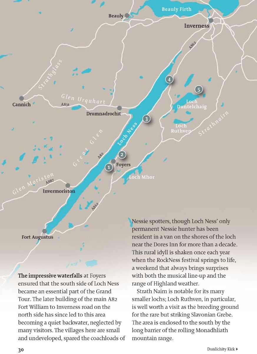
The Slavonian Grebes on Loch Ruthven are a strong attraction for keen twitchers, but it is the red kites of the Black Isle that are probably the region’s best known avian inhabitant, easily identified by their distinctive forked tail. A heart-warming success story, these impressive birds were reintroduced under a programme which began in 1989. Today, there are approximately 50 pairs in the area. Persecution continues to deplete their numbers, however, and studies suggest the Black Isle population might now have topped 300 pairs if it were not for illegal poisoning. Otters are prevalent in much of the area, although they are elusive creatures best spotted in the water. Curiously, one of the best places to spy them is from the road end in the South Kessock area of Inverness (see page 88), where regular wildlife spotters wait patiently from the comfort of their cars, armed with binoculars. The Black Water, featured in the Rogie Falls and Silverbridge routes (see pages 62-64), offers a chance to watch for leaping salmon as they make their way upstream to spawn in the late summer and autumn. The surrounding forests are said to be a stronghold of the native Scottish wildcat, though sightings are very rare.
| Series | 40 Favourite Walks |
|---|---|
| Brand | Pocket Mountains |
| Continent | Europe |
| Country | Scotland |