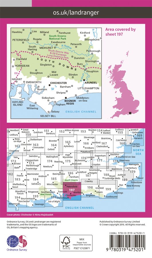
OS Landranger Active - 197 - Chichester & The South Downs
Ex VAT (Free UK Delivery Over £125)


| Unit RRP: | £16.99 |
| VAT Rate: | 0% |
| Unit Price (ex. VAT): | £9.34 |
| Unit Price (inc. VAT): | £9.34 |
| Units in Case: | 1 |
| Profit per Unit: | £7.65 |
| Profit per Case: | £7.65 |
| Profit on Return (%): | 45.03% |
| Mark Up (%): | 81.91% |
Calculate Your Profit:
| Profit per Unit: | N/A |
| Profit per Case: | N/A |
| Profit on Return: | N/A |
| Mark Up (%): | N/A |
OS Landranger Map Active 197 Chichester & The South Downs
1:50,000 scale
2 cm to 1 km or 1¼ inches to 1 mile
The Ordnance Survey Landranger Map - Active series provides a tough, durable and weatherproof alternative to Ordnance Surveys versatile OS Landranger map. This encapsulated version offers the same detailed information and mapping as the popular OS Landranger maps. Packed with informative detail, designed to enhance your day trip or short break whilst providing increased integrity, this series is ideal for map users likely to use the maps on a regular basis. The maps are covered in a lightweight protective plastic coating that can be written on allowing routes to be highlighted using a suitable washable ink.
The OS Landranger Map - Active is the ideal map for planning the perfect day out. Whether visiting town or country, a wealth of visitor attractions, including National Trust properties, museums, gardens, golf courses and castles, are illustrated. The 1:50k scale mapping provides an ideal compromise between detail and coverage whilst still retaining topographical and contour properties.
197 Chichester & The South Downs featuring :-
South Downs
South Downs Way
Sussex Border Path
Wey-South Path
Wayfarer's Walk
Solent Way
Hangers Way
Staunton Way
Monarch's Way (Book 3)
South Downs Way (National Trail)
Hampshire
West Sussex
Bognor Regis
Chichester
Havant
Littlehampton
Midhurst
Petersfield
OS Landranger Map - Active features include:
• Roads, railways and ferry routes
• Paths, national trails and cycle routes
• National Trust areas
• Forestry Commission land
• National Parks
• Tourist information and places of interest
• Camping and caravan sites
• Picnic areas and viewpoints
• Rights-of-way information for England and Wales.
This series features 204 maps each covering 40km x 40km (25 miles x 25 miles)
How to access the digital version of this map
This map comes with a digital version which you can download to your smartphone or tablet.
Go to OS.uk/redeem for more details (terms and conditions apply).
Scratch off the panel on the inside cover of the map to reveal a code, you are then just three easy steps away from downloading your digital map.
If the scratch panel has already been scratched off or if you have any problems downloading your map, please call the OS Customer Service Centre on 03456 050505.
| Series | Landranger Active Maps |
|---|---|
| Scale | 1:50,000 |
| Activity | Cycling, Horse Riding, Walking |
| Brand | OS |
| Continent | Europe |
| Country | England, UK |
| Region | Sussex |