OS Urban Map Series - Walk London
Ex VAT (Free UK Delivery Over £125)


| Unit RRP: | £9.99 |
| VAT Rate: | 0% |
| Unit Price (ex. VAT): | £5.99 |
| Unit Price (inc. VAT): | £5.99 |
| Units in Case: | 1 |
| Profit per Unit: | £4.00 |
| Profit per Case: | £4.00 |
| Profit on Return (%): | 40.04% |
| Mark Up (%): | 66.78% |
Calculate Your Profit:
| Profit per Unit: | N/A |
| Profit per Case: | N/A |
| Profit on Return: | N/A |
| Mark Up (%): | N/A |
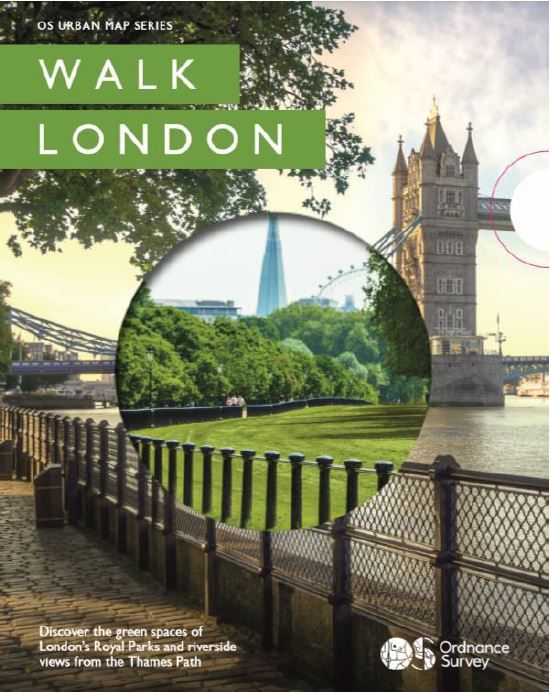
Ordnance Survey - Urban Map Series - Walk London
Walk London is the first map in the OS Urban Map series. This London title contains artwork and mapping that is both beautiful and informative and ultimately encourages customers to explore London’s green spaces and waterways.
Printed as a strip map over 11 panels Walk London incorporates a unique concertina fold design so it can be read like a book or unfolded to reveal a section of the Thames Path on one side and some of London’s spectacular Royal Parks on the reverse.
These colourful 3D artworks of the Royal Parks and Thames Path maps along with our recommended authored routes take the walker through the points of interest and history of the city’s river and green space. Walk London is a new urban map designed for Londoners wanting to get into local green spaces and improve their health but also for the tourist audience wanting to discover the rich history and open spaces of this magnificent city. And, with accessible routes it is a map for the whole family.
For anyone who loves the hustle and bustle of the city but craves wide-open spaces, this beautiful picture map provides routes and information to help explore London in a new and exciting way.
Key features of Walk London
- Expert guided accessible routes
- Beautiful 3D illustrations
- Historical landmarks/Museums/Galleries/Cultural highlights
- Transport links (with disabled access), train/bus stops and relevant ferry boat links
- Disabled and standard toilets/baby changing facilities
- Tourist information kiosks/ centres
- Food and drink, cafes and restaurants
- Standard/disabled car parks
- Playgrounds
- Sport and leisure facilities e.g. boating lakes, and tennis courts.
| Series | Urban Map Series |
|---|---|
| Activity | Walking |
| Brand | OS |
| Continent | Europe |
| Country | England |